
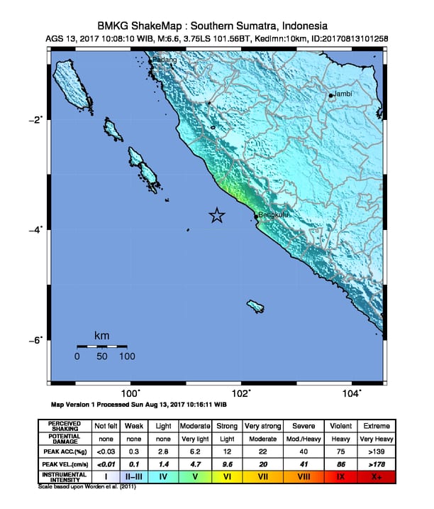
At 10:08 am on Sunday 13 August, a magnitude 6.4 earthquake occurred off the coast of Sumatra, about 75km to the west of Kota Bengkulu (Figure 1). The earthquake occurred at a depth of around 35 km, and resulted in strong shaking in the Bengkulu and Seluma districts. The earthquake was felt as far away as Padang and South Sumatra but did not generate any tsunamis.
In North Bengkulu (the area closest to the quake) strong shaking was felt for about 10 seconds, causing some panic amongst locals. The most common response was to quickly move outdoors. Some minimal damage to buildings was observed, but there were no reports of casualties. The earthquake resulted in power outages in some parts of the district.
Bengkulu BPBD activated in response to the event, with staff undertaking field checks, and reporting for duty if a wider response was required. They were stood down later in the day.
There is significant seismic risk for many communities on the island of Sumatra, and the districts involved in the StIRRRD program have included a number of activities in their DRR Action Plans to better understand and reduce this risk. StIRRRD alumni are also working on a range of other seismic risk reduction activities. For example, at the University of Bengkulu, Dr. M. Farid is working to understand and map liquefaction hazard; and Universitas Andalas (Padang) staff are trialing a method to retrofit un-reinforced brick buildings with wire mesh, to improve their ability to withstand seismic shaking.