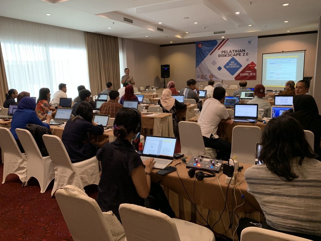
RiskScape 2.0 made its international debut at a workshop preceding the International Conference on Urban Disaster Resilience in Palu, Sulawesi, on 24 April 2019. RiskScape is an impact and loss modelling tool that performs complex calculations quickly and simply, providing outputs that assist in decision-making.
The workshop was a full-day event, covering the concepts of risk and impact modelling, the evolution of RiskScape from version 1 to 2, and using RiskScape 2.0 to assess building impacts from a tsunami affecting the coastal areas of Palu. The tsunami hazard modelling used was an approximation of the inundation extent of the 28 September 2018 tsunami, which devastated the coastal areas of Palu and Donggala. Approximately 30 participants from diverse backgrounds, including the Universitas Tadulako, Universitas Gadjah Mada and Palu City local government, attended the workshop.
Depending on user preferences, the RiskScape software was provided in two languages: English and Bahasa Indonesia. Participants came prepared with their own laptops. The current version of RiskScape is a command line interface, which requires users to type in commands rather than interact with a graphical user interface (planned for development later this year). Despite the learning curve, participants were able to successfully run the software and visualise the results using GIS software.
The workshop was not only the first time RiskScape 2.0 had been used outside New Zealand, but the first time it had been demonstrated and used beyond the research and development teams. Participants were highly engaged throughout the day, and there was significant interest in how the software could assist with decision-making. The case study of tsunami inundation in Palu served as a useful example of the applicability of the tool to the local context.
Author: Michael Goldsmith
As reported in October, our work for StIRRRD sometimes provides unexpected opportunities to support the communities we work with – outside of our normal resilience projects.
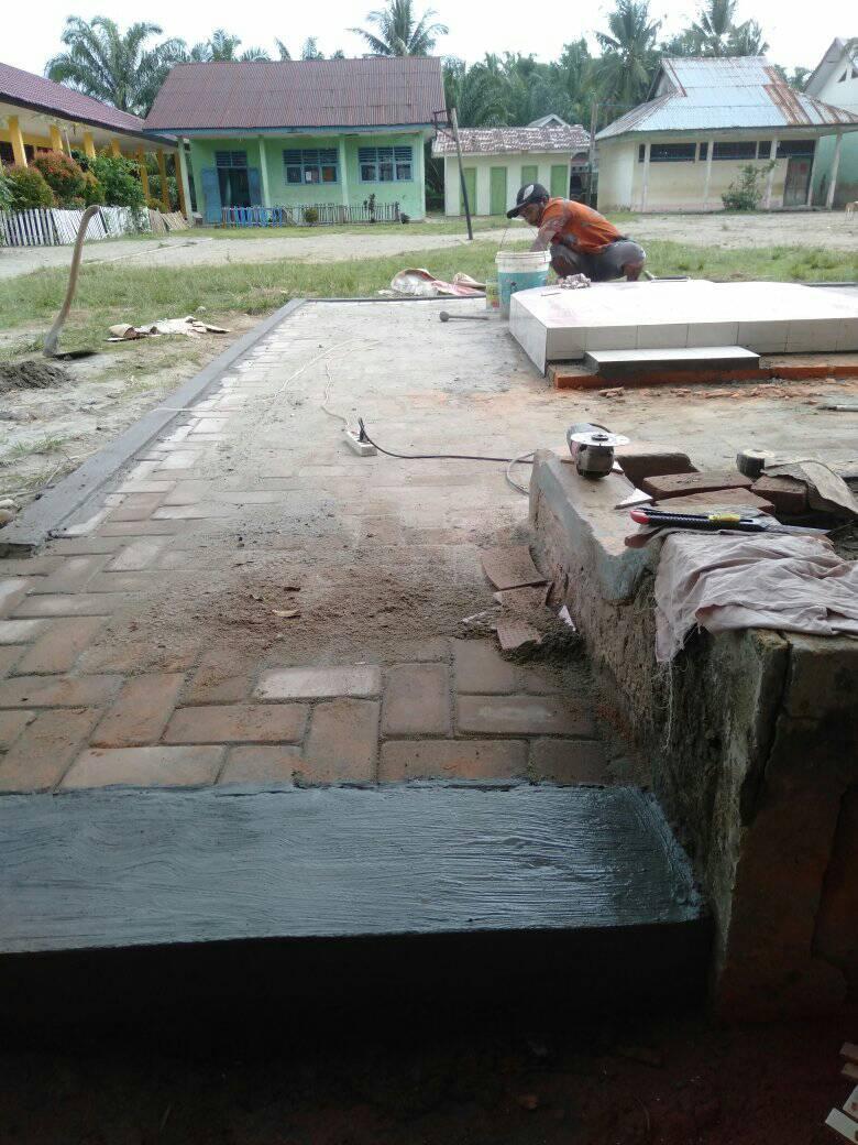
A StIRRRD team member was asked to present to the Balclutha Rotary Club about the project, focusing on the community-scale DRR work undertaken in the village of Rawa Indah. Rotary kindly offered to donate $500 to Rawa Indah School to help pave the central courtyard, which is dusty and pitted in the dry season, and becomes very muddy during the rainy season. The courtyard also serves as the evacuation meeting point for the entire school in the event of an emergency.
This small donation has proved invaluable to the school, and they immediately got to work using the funds to improve a section of the yard. They have plans to raise more funds, and extend this work across the entire yard.
Sometimes it is the little things like this which can make a big difference in people’s everyday lives, and it has certainly provided a great deal of satisfaction for the StIRRRD team which helped to coordinate it. The photos show that is it has given a much-needed lift to the school environment.
Written by Sheng-Lin Lin, Risk Engineer, GNS Science
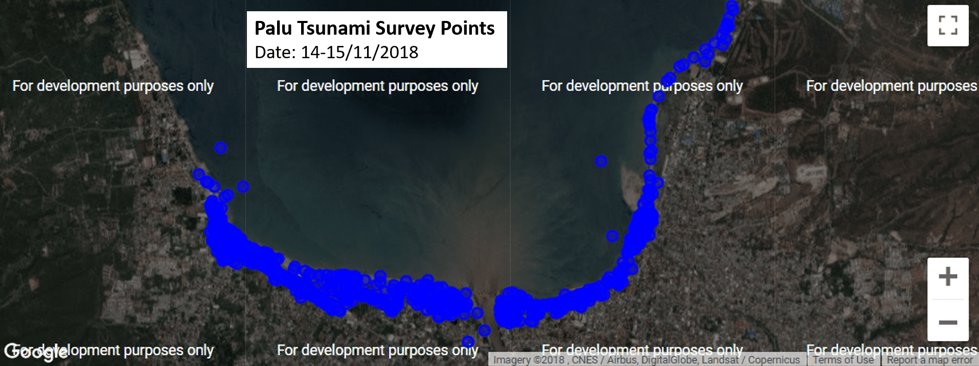
The tsunami survey is a research initiative funded by the New Zealand RiskScape programme (www.riskscape.org.nz) in partnership with the University of Canterbury and theStIRRRD programme.
Summary -15/11/2018
Yesterday (16/11/18) morning we continued ourdamage survey in the east side of bridge but further north, as shown in thesurvey point distribution.
In the afternoon, we visited Balaroa, one of the
liquefaction areas near Palu.
As shown in the image, the damage/impact is impressive and very sad.
We thought some damage might come from
liquefaction, but the majority of the houses were swallowed/damaged by the
landslide/mudslide as the scale is unbelievable.
I’m on the way back to Wellington, but the team will continue their field survey today (Saturday), and head back Jakarta on Sunday,have debrief meeting on Monday in Jakarta with ITST, and then head back NZ on Monday late afternoon.
Written by Sheng-Lin Lin, Risk Engineer, GNS Science
The tsunami survey is a research initiative funded by the
New Zealand RiskScape programme (www.riskscape.org.nz)
in partnership with the University of Canterbury and the StIRRRD programme.
Summary – 14/11/2018
Today (14/11/2018) is our first day on the ground
to capture the tsunami impact using RiACT.
We have Alamsyah (lecturer) and 4 students from UNTAD Engineering Dept with us to capture the impact as well as translation.
As shown in the below image, today’s survey is concentrated in the area between Palu Bridge and Palu Grand Mall.
After we spent the day surveying, we were invited to attend a community meeting to discuss and share our learning from the field survey as well as our experiences in NZ.
Over 40 people (incl. Pak Singgih & Dr.
Abdullah, 2 key personnel in StIRRRD project) attended to learn the tsunami
impact survey as well as share their experience and suggestion.
During the meeting, a scientist from Indonesian
Science Institute gave a brief overview of recent post-tsunami survey
activities in Palu, followed by questions/comment from community members.
The meeting was great, the audience was very
engaged and willing to share their experience (incl. losses) during this event.
We will continue our survey in the Palu, we will first fill the area between the Grand Mall and our hotel (Swiss-belhotel), then probably move to east Palu bay this afternoon.
Written by Sheng-Lin Lin, Risk Engineer GNS Science
The tsunami survey is a research initiative funded by the New Zealand RiskScape programme (www.riskscape.org.nz) in partnership with the University of Canterbury and the StIRRRD programme.
Summary – 13/11/2018
Day one the survey team traveled to Palu City from Jakarta on an early morning flight. Gumbert Maylda Pratama met the team at Palu airport before attending a meeting with colleagues at Tadulako University (UNTAD). The New Zealand-Indonesian team carried out a survey recognisance trip along the Tawaeli to Palu City coastline, stopping at key sites such as Kampung Nelayan to observe road infrastructure damage.
Activities Summary
Travel from Jakarta to Palu arriving at 6:30am.
Visit Palu River Bridge to see the reconstruction activities.
Meeting with Amar Akbar Ali, Pak Ketut, Andi Rusdin and Ida Sri Oktaviana at UNTAD Engineering Department.
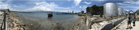
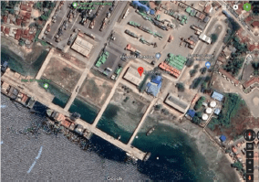
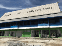
Travel to Port of Pantoloan with Pak Ketut and Ida Sri Oktaviana for observations of tsunami flow depths and building damage.
Travel to Palu City along coastal road, stopping at Kampung Nelayan to observe road and sea wall damage
Tsunami Hazard Observations
Tsunami flow depths above ground and inside buildings were observed and measured for buildings and surrounding features at Port of Pantoloan. Flow depths were observed onsite but not systematically recorded using a field data collection application.
Tsunami Flow Depths
Several measurements from water marks inside ferry service terminal building (Pelabuhan Palu – see image below) indicates flow depths may have reached 1.7m above ground. This height was consistent with debris deposited on wire-mesh fencing within 20m of terminal building.
Tsunami Damage Observations
Building and infrastructure damage was observed during recognisance along the coastline from Tawaeli to Palu City. The survey team made two stops at Port of Pantoloan and Kampung Nelayan based on the recommendations of UNTAD colleagues. Damage characteristics were observed but not systematically recorded using a field data collection application.
Buildings
Port of Pantoloan
Flow depths inside ferry terminal buildings reached maximum of 1.7m, though lower depths of 0.33m were measure from debris marks indicating still water levels.
No structural damage observed for one and two storey concrete masonry buildings, with non-structural components more readily damaged. Non-structural damage observed on first floor level includes:
First floor window frames and glass completely damaged where flow depths exceed 1.5m.
Air conditioning service wiring and condenser units completely damage when located low to ground (i.e. <1m).
Tiles removed from first floor level, floor material and foundations undamaged.
Damage to internal doors i.e. warping and swelling.
Fixtures and fittings including joinery were removed from buildings.
Electrical items including, power socket and switches were inundated and remained in situ, although replacement or reconditioning would be required before reuse.
Minor damage (e.g. impact cavities, stripped paint) to external walls due to floating objects. No cracking observed.
Noted that the ferry service was moved to another further north port prior the Palu-Dongala earthquake tsunami, hence limited human impact during the event.
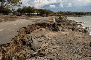
Tawaeli to Palu City
Extensive damage on low-lying coastal land, with many buildings potentially experiencing collapse or washed away (we will need to verify with other researchers).
A number of damaged building sites identified for survey activities.
Caution will need to be exercise during any survey activities as many residents who lost homes have set-up camps.
Roads:
Many roads within observed inundation area have performed well (DL0-DL1). Localised damage was observed (DL2-DL3).
DL2– DL3 (Moderate – Complete) damage observed South of University of Tadulaku
Extensive seawall scour observed with loss of one or two lanes of road. Blow out observed at culvert (DL2).
Peeling of pavement observed (DL1).
Electricity:
Many utility poles were observed to have performed well (DS0). Bolted embedment type poles observed at Pontaloan Port (where damage was observed on other assets)with no signs of damage (DL0)
Localizedareas of damaged utility poles (DS2) observed.
Electricitypoles South of University of Tadulaku observed with lines pulled from poles(DL1 – DL2)
Earthquake Damage Observations
Though the focus of this survey is Tsunami impact to buildings and infrastructures,earthquake damage was also observed and recorded when available.
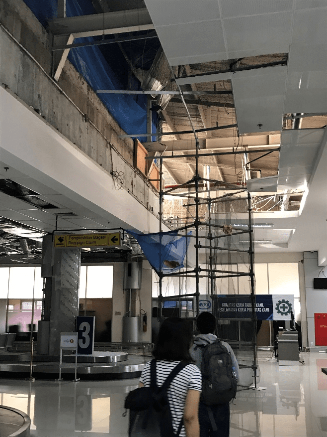
Palu Airport:
The airport is still operating (only ground floor, the upper floor was closed) though its substantial non-structural damage and wall cracks.
Palu Bridge:
The demolition of the damage bridge is underway as shown below (left).
A multi-story building nearby was also damaged by earthquake shaking (and tsunami?!)
Tadulako University:
70% of buildings in the campus were affected by the earthquake shaking. Some of them was closed due to its severe damage and safety issue, such as the Faculty of Engineering building shown below.
Students and staff are back school now. But with limited facilities after the earthquake, some students and staff are relocated to other universities already.
Pak Ketut and his team had conducted detailed assessment of damage buildings in Tadulako University as well as buildings within Palu city.
Port of Pantoloan:
Some damage in Port of Pantoloan is believed to be caused by earthquake shaking, such as the collapse of crane (left) and the collapse of brick wall (right).
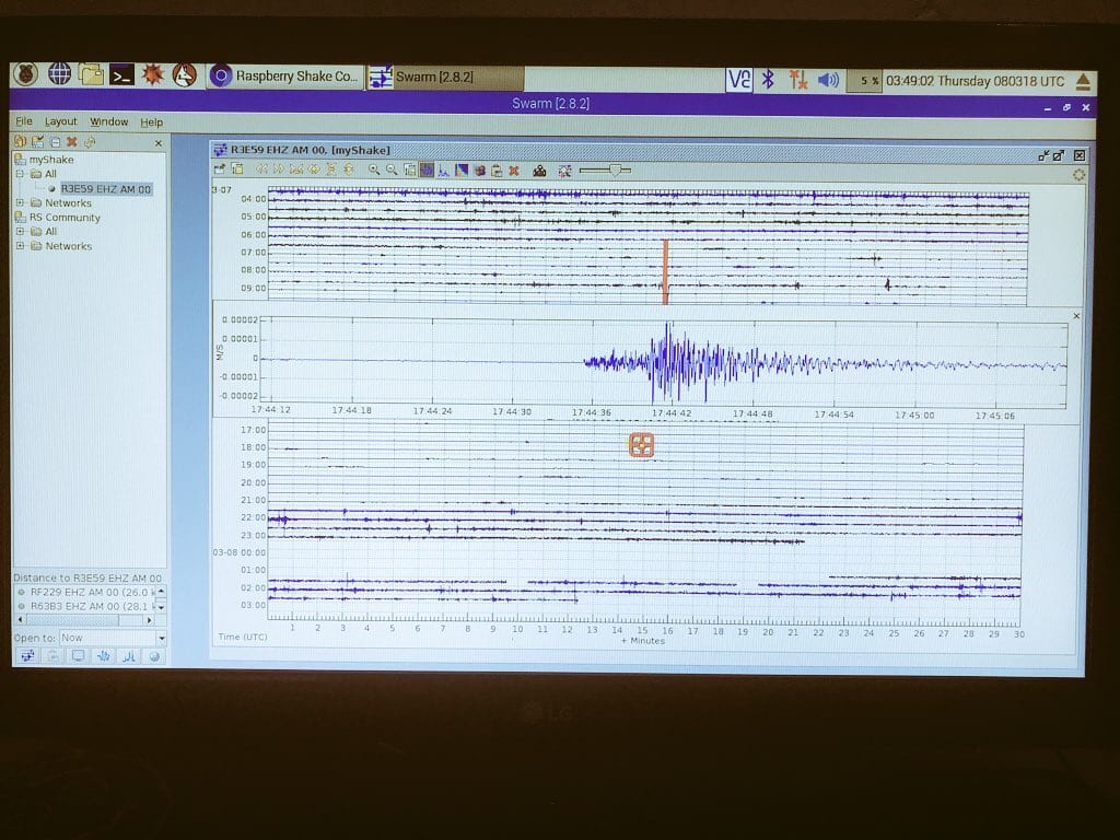
No-one involved in the Seismometers in Schools project wanted to see their work put into action as quickly as it was in Palu. In March 2018, three schools in the City of Palu had Raspberry Shake seismometers installed; on 28 September, a 7.5 magnitude quake in the North Sulawesi subduction zone and a subsequent tsunami killed at least 2100 people in Palu City, Donggala and Sigi. Nearly 700 are still missing and close to 80,000 people remain displaced.
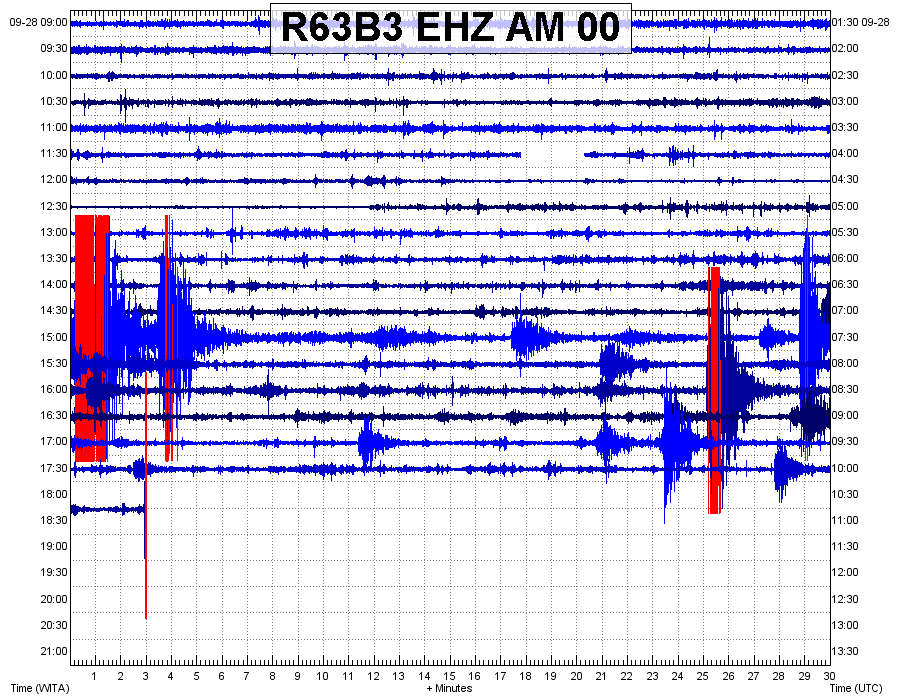
A couple of days later, Richard Woods from the StIRRRD team noticed that the Raspberry Shake at the SMA Negeri Model Terpadu Madani (located in the north of the city of Palu) was back online, as power was restored to the school.
The seismometers in the three schools helped to build a picture of what happened that day. The severity of the shaking was obvious, and we can only imagine how terrifying the earthquake must have been.
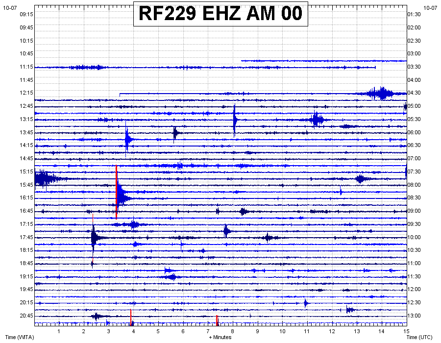
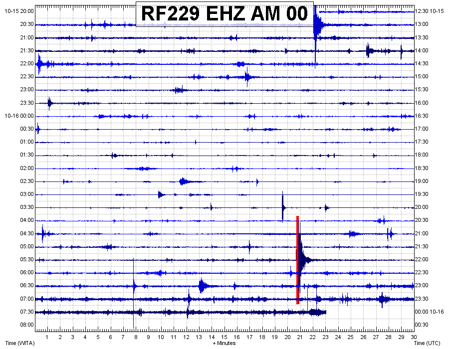
The first image below shows the seismic trace up until the M7.5 struck just after 6pm. You can see the M6.1 foreshock earlier in the day and the aftershocks in between the two earthquakes. The second image shows the seismometer had power restored just after 12.15pm on 07/10, and the third image shows the UNTAD seismic trace on the 16th of October, interspersed with many aftershocks.
The ‘Raspberry Shake’ seismometer installed at SMA Negeri Model Terpadu Madani school in March, captured the Seismic trace up until the M7.5 struck just after 6pm on September 28. You can see the M6.1 foreshock earlier in the day and the aftershocks in between the two earthquakes.
A second image from the Raspberry Shake at SMA Negeri Model Terpadu Madani, which shows that the seismometer had power restored just after 12.15pm on October 7.
The image above shows that aftershock sequence is continuing, on seismic trace captured by the raspberry shake on 16 October.
Richard then noticed that the Raspberry Shake located at MAN 1 school in the city of Palu, had also come back online, and like the first image above, the severity of the shaking is very clear.
The Seismic trace up until the M7.5 struck just after 6pm on September 28 captured on the Raspberry Shake seismometer at MAN 1 School in Palu.
For StIRRRD program leader Michele Daly and the wider team, the realities of the recent earthquake and tsunami are confronting. It’s one thing to be aware of the destructive potential of these natural hazards, but quite another to see events play out so soon. The StIRRRD team had visited Palu just six months before, and no-one could have predicted having to deal with such severe impacts so soon.
Michele described it as ‘heart-breaking’ to see so much destruction and human cost. But she was also amazed at how rapidly people have mobilised to support each other. She says that going by her experience of the wonderful people of Palu, she is sure this will continue throughout the recovery.
So, what are GNS Science and the StIRRD team doing to help?
The StIRRRD team is part of the response effort, supporting the Indonesian government and in-country partners with their response efforts. GNS Science has many experts in response and recovery following earthquake and tsunami events, and New Zealand’s Ministry of Foreign Affairs and Trade (MFAT) asked GNS and the StIRRRD team to lead a NZ inclusive approach, providing Palu with technical support in the transition from response to rehabilitation and recovery.
The immediate focus is to support MFAT and local agencies in Indonesia to carry out earthquake damaged building assessments and landslide risk assessment. The StIRRRD team are working with GNS experts and liaising with a variety of NZ and Indonesian partners, and this work is likely to continue in the longer term – with an emphasis on resilience and building back, better.
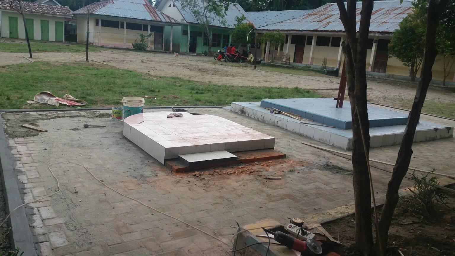
Sometimes our work for StIRRRD throws up unexpected opportunities to support the communities we work with – not just in our normal resilience projects, either. The story of Rawa Indah school shows what can happen when scientists and communities work together – with a little fundraising help from our friends.
During our three visits to Rawa Indah in Seluma this year, the StIRRRD team noticed the local school needed more than a bit of help. (You can read more about our visits to the village here (http://stirrrd.wg.ugm.ac.id/2018/03/05/initiating-tsunami-awareness-community-engagement-rawa-indah-seluma/).
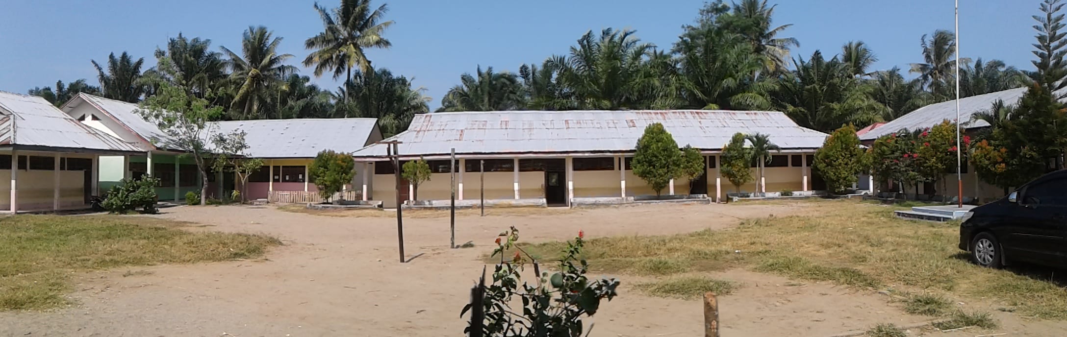
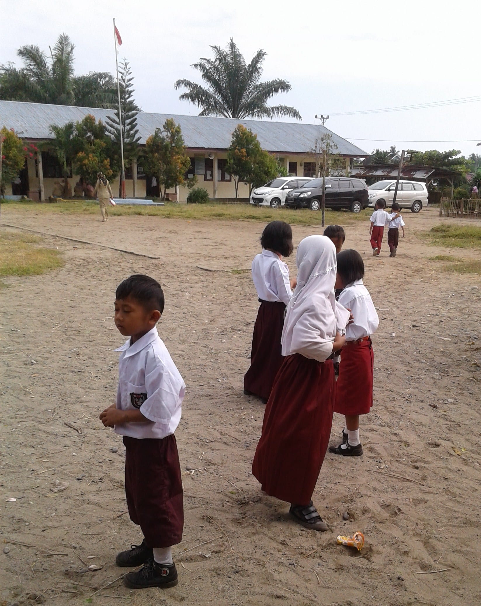
The buildings and grounds of Rawa Indah school were in urgent need of rehabilitation. Take the school yard, for example. The School Principal, Laurensius Pambudi, had previously told us this was a priority project for them, as it is the evacuation meeting point for the entire school in the event of an emergency. The yard is not currently suitable for this purpose, as it is dusty and pitted in the dry season, and becomes very muddy during the rainy season.
Photos showing the condition of Rawa Indah School Yard. Photo credit: Michael Goldsmith.
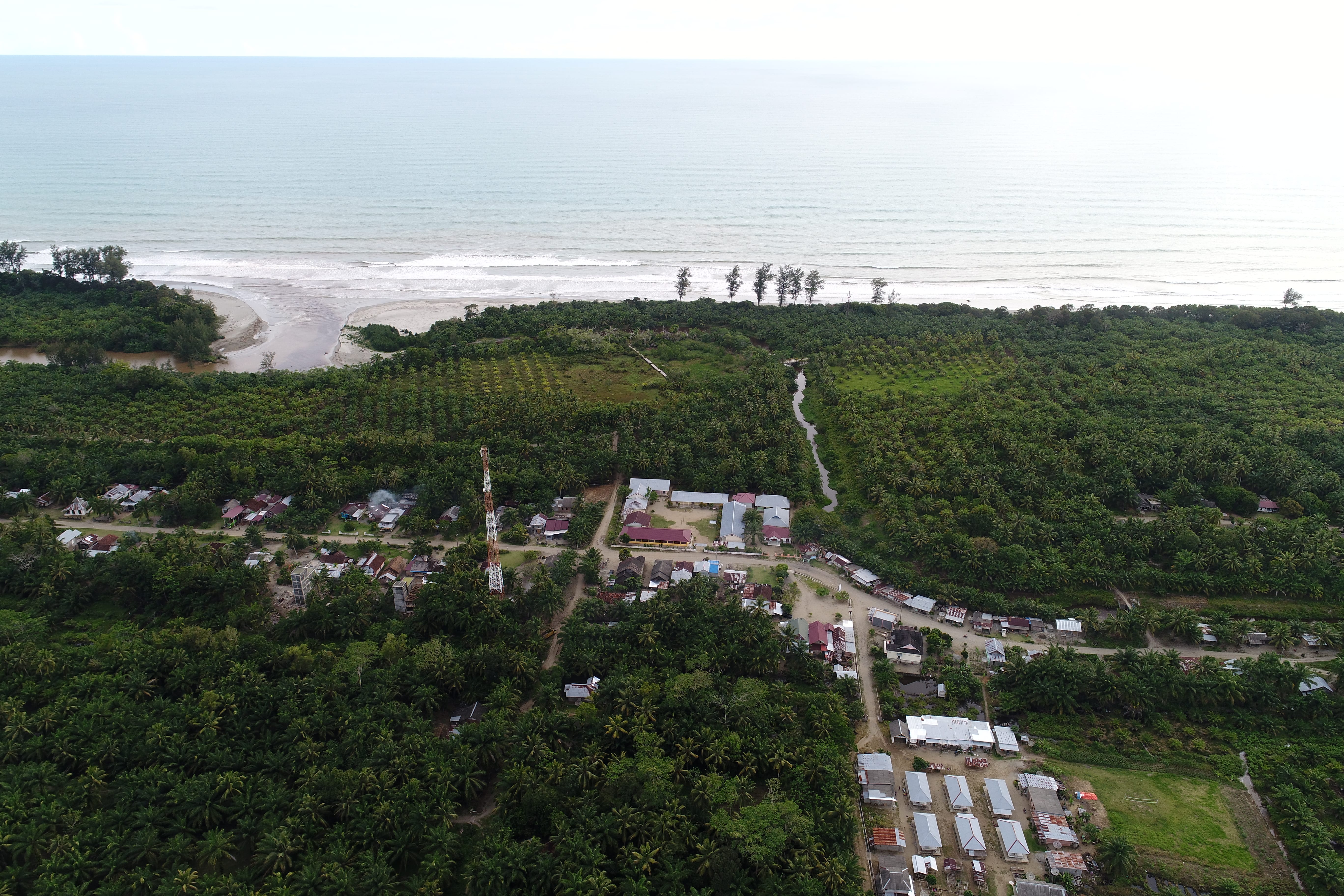
Rawa Indah School from the air (centre of image). It is located near the coast, and therefore has a high risk from tsunami. Photo Credit: Egy Erzagian.
Back home in NZ, one of the StIRRRD team members was asked to present to Balclutha Rotary Club about StIRRRD, particularly about the DRR work being undertaken in Seluma. Following this presentation, Rotary offered to donate $500 to Rawa Indah School so they could pave the yard.
Balclutha Rotary supports both local and international projects, particularly in developing nations. In the past they’ve supplied emergency response kits and supported an expert dental and educational support group to work in Cambodia. Rotary member Gabrielle Schou said that the project fitted well with Rotary’s core values, and supporting projects aligned to Rotary’s six areas of focus (includes basic education and child health) is very important.
The StIRRRD team were more than happy to facilitate this donation, and we will continue to look for other opportunities which can help Rawa Indah become more resilient. We made some great friendships within the village through this project, and look forward to seeing their progress in coming years.
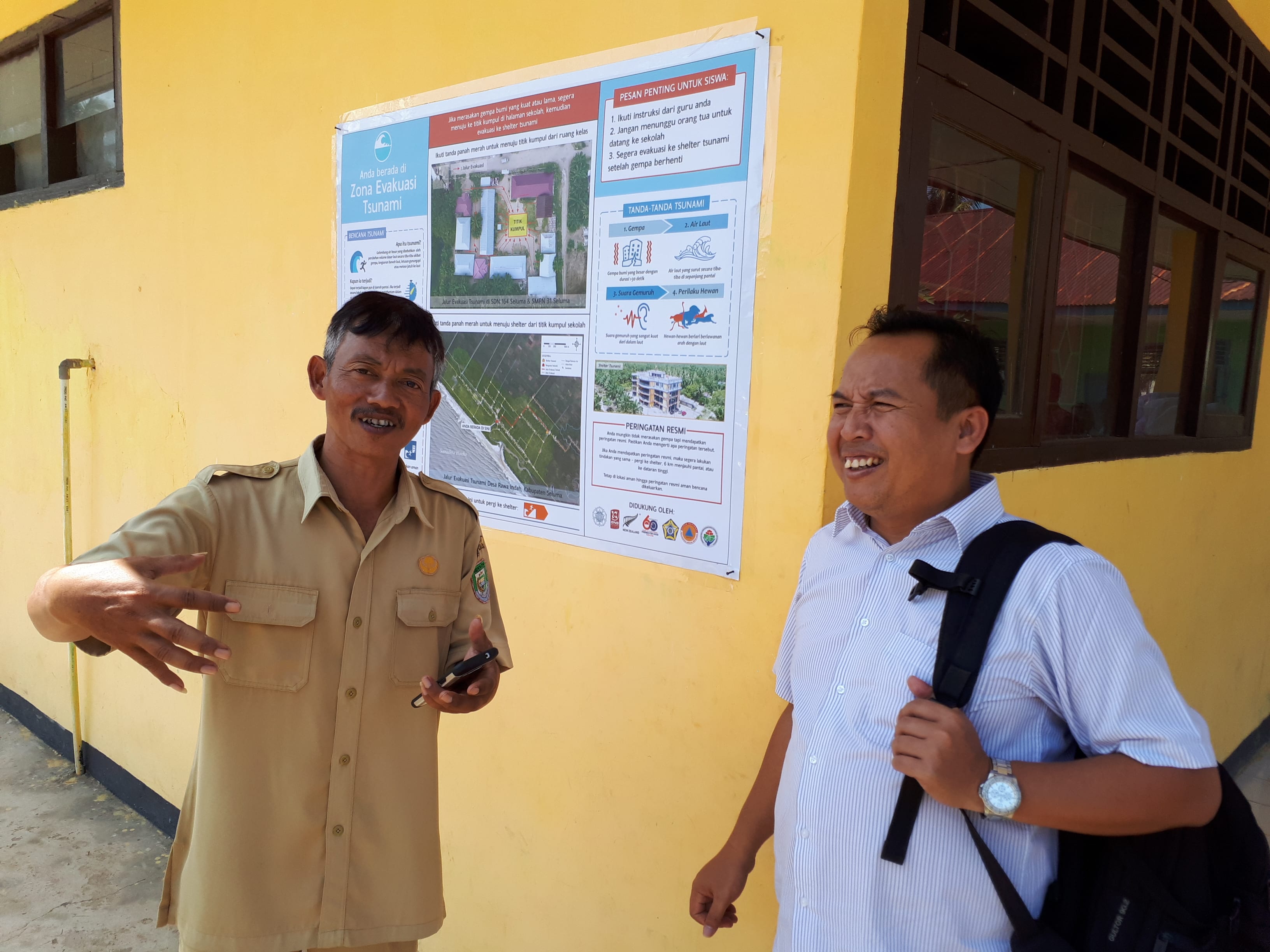
School Principal Laurensius Pambudi (left) and StIRRRD Province Coordinator Dr. Wahyu Wilopo. An Information Board prepared specifically for the School as part of the Tsunami Preparedness project can be seen on the wall. Photo credit: Phil Glassey
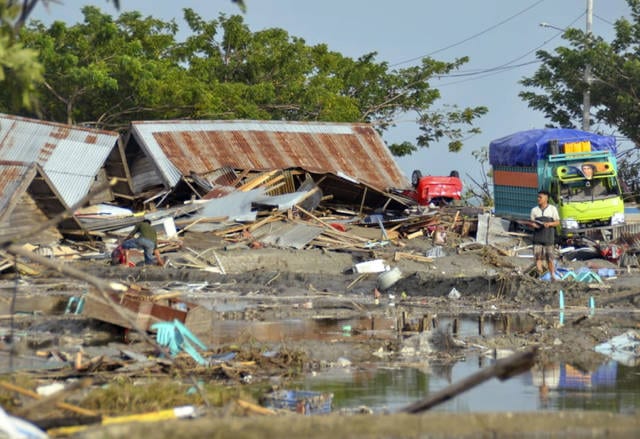
A man stands amid the damage caused by a tsunami in Palu, Central Sulawesi, Indonesia, Saturday, Sept. 29, 2018. [source: Associated Press Photo]We can only imagine how horrific it currently is for the people of Central Sulawesi, following the magnitude 7.5 earthquake that struck Donggala and Palu on late Friday afternoon 28th Sept 2018. The damaging tsunami which struck Palu Bay at incredible speeds a reported 30mins after the quake happened, caused wide spread destruction. This was on top of significant damage due to the earthquakes north of the city and also along the Palu-Koru Fault. Tsunami waves as high as 5.5m crashed ashore in the already damaged city, destroying buildings, smashing vehicles and killing hundreds of people.
Palu and Donggala are both StIRRRD districts and the StIRRRD team have been working in these areas over the past 7 years. We have many colleagues and friends in the community and we wait anxiously for news of how they are.
The team were last in Palu and Donggala in March 2018, installing seismometers in 3 schools in the area plus one at the university. The seismometers are intended as an educational tool to help the students understand the seismology of the area and to stimulate discussions about earthquakes and tsunami; their causes, hazard mitigation, preparedness and response actions. Students learned the importance of natural warnings for tsunami, and how to Drop, Cover and Hold. We hope these discussions in March were able to help those teachers and students with their actions in this event.
The current death toll has exceeded 840 and is expected to rise sharply over the coming days and weeks, leaving the StIRRRD team deeply concerned for our friends and colleagues who we’ve not been able to contact. In addition to the death toll, an estimated 2.4M people have been affected, with six hundred people hospitalised and 48,000 people displaced. The isolation of affected communities and the scarcity of resources is making response efforts difficult.
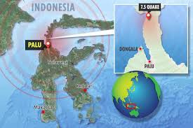
Map and location of Palu and Donggala. [source: The Sun]The tsunami was bigger than anticipated and the generation mechanism likely more complex than originally thought. The fault that ruptured on Friday was a so-called strike-slip fault, in which the earth movement is largely horizontal. That kind of movement would not ordinarily create a tsunami. However, a strike-slip fault might have some amount of vertical motion that could displace seawater. The fault’s rupture zone, may pass through an area where the seafloor rises or drops off, so that when the fault moves during the quake, it pushes seawater in front of it. Another possibility is that the tsunami was created by an undersea landslide, caused by the intense shaking. Determining the exact cause of the tsunami will have to wait until the sea floor can be examined. The shape of Palu Bay has no doubt contributed to the size of the waves in Palu, with the waves’ energy being focused (amplified) along the hairpin shaped bay.
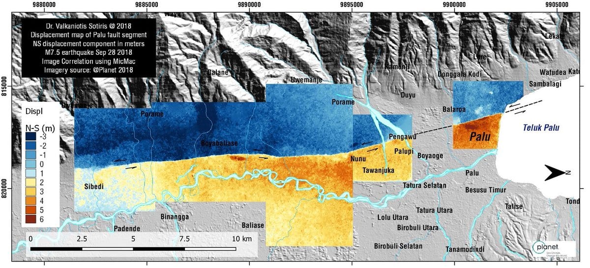
Map of the Palu-Koru Fault showing the direction of displacement and areas with the greatest shaking. [source: Dr Valkaniotis Sotiris @Planet 2018] In the 7 years the StIRRRD team have been working with Palu, and more recently Donggala, the districts have been making steady progress in improving their resilience. The team have been impressed by the dedication of the local government staff working in this field and Tadulako University’s efforts to improve their teaching programmes.
Palu and Donggala have been working towards the implementation of Risk Reduction Action Plans – a set of actions inspired by NZ and Indonesia working and learning together. Since they have been introduced, they have resulted in a number of enhancements: expansion of earth sciences and risk modeling at Tadulako University, a new public education programme, micro-zonation studies in Palu, increased budget for risk reduction, the establishment of a spatial mapping capability in the planning department and a collaborative research and awareness raising programme into the Palu-Koru Fault (http://voinews.id/index.php/component/k2/item/2109-palu-koro-expedition-unveils-the-great-earthquake-potential-in-central-sulawesi ).
Tadulako University was also about to host its first international conference on Urban Disaster Resilience in November 2018: (http://fatek.untad.ac.id/icudr/)
It’s still early days, and building resilience requires a sustained effort over generations. This combined earthquake and tsunami event has been devastating. This has always been possible in this part of the world but it’s not what you ever anticipate will actually happen. This will set Palu and Donggala back, but it has redoubled our resolve to work with our friends and colleagues there to look to the future and ensure risk reduction is built into the recovery process.
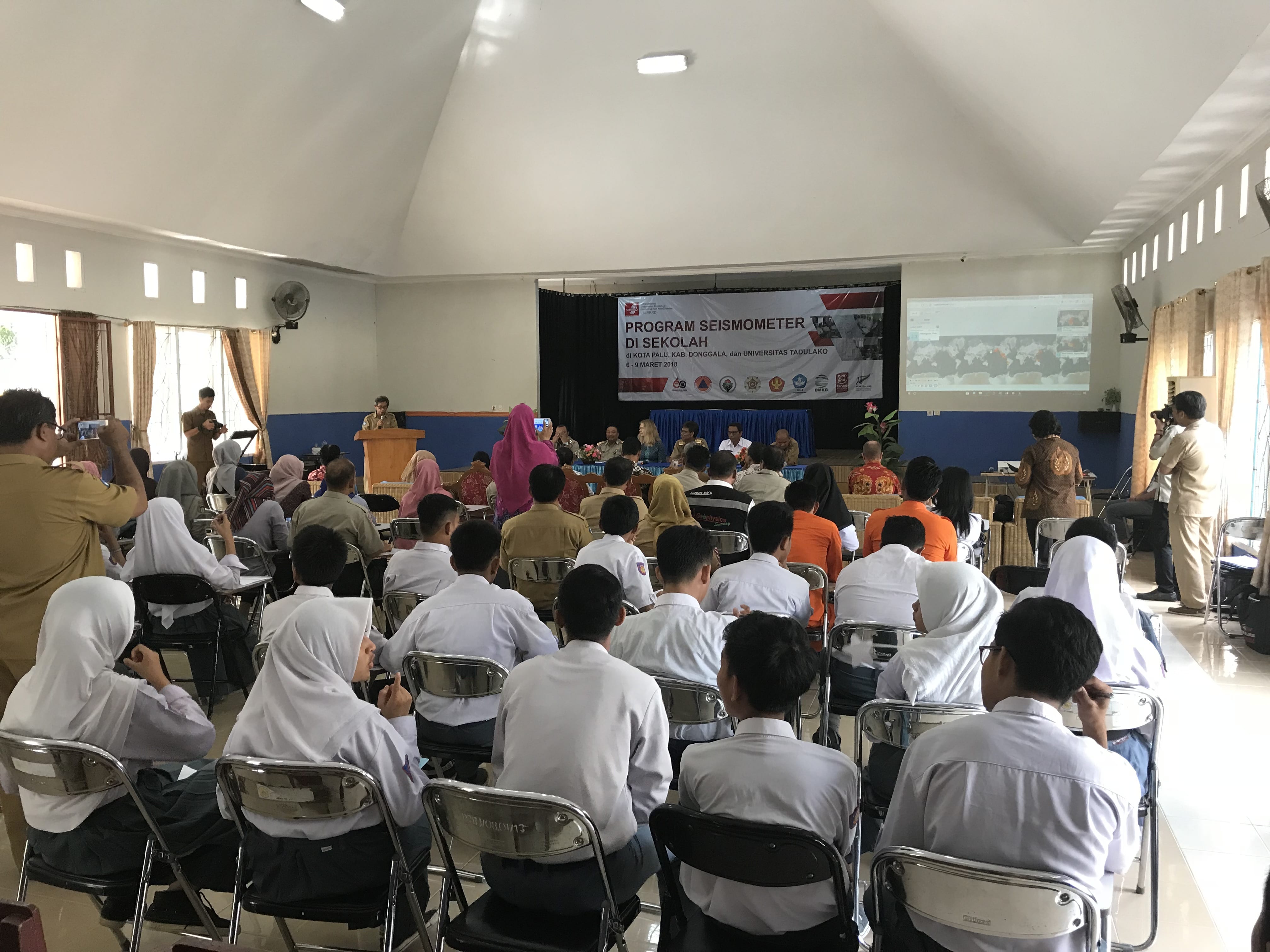
During the week 5 to 9 March, StIRRRD team members were based in Palu, Central Sulawesi to launch Indonesia’s first Seismometers in Schools (SIS) programme. Seismometers in Schools is an education initiative already present in Australia, New Zealand and the United States which involves installing seismometers in schools as tools to increase awareness of seismic hazards and risks. Information from the seismometers can be analysed by mathematics, physics or geography students to assess earthquakes recorded locally or from around the world.
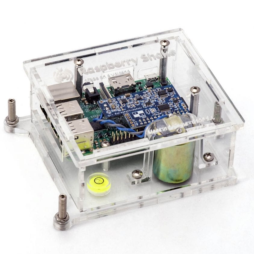
Raspberry Shake seismometers are commonly used in school education programmes around the world.
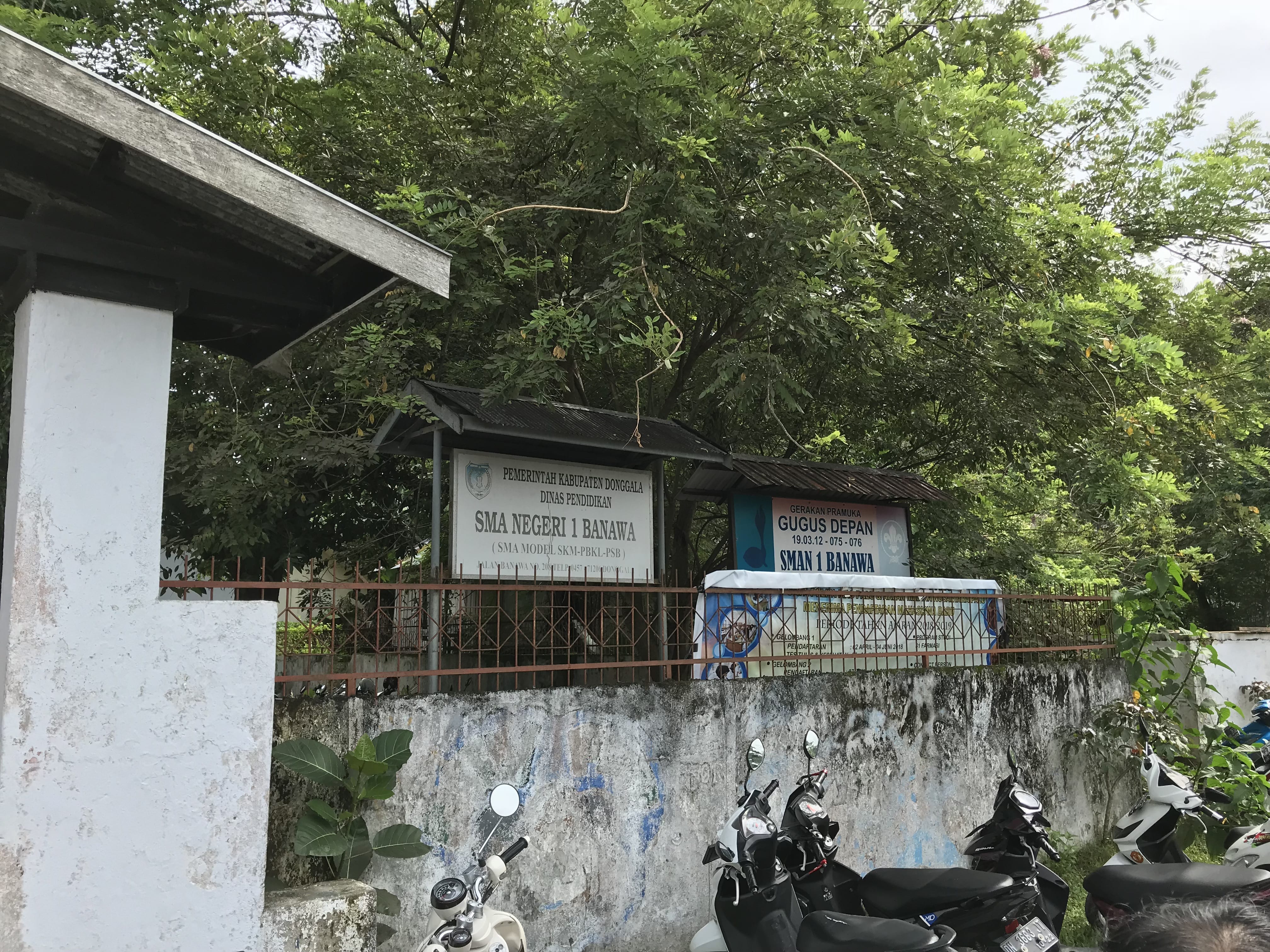
As a part of the StIRRRD programme, the pilot SIS programme has been established in Central Sulawesi province with seismometers installed in four schools and a more sophisticated three component device installed at the University of Tadulako, Palu. The participating schools are SMA Negeri Model Terpadu Madani and MAN 1 in Palu City, SMA N 1 Banawa in Donggala and SMA N 1 Bahadopi in Morowali. Only public schools were selected to be involved in the pilot study. All installations were undertaken in the first week of March, except for Morowali which will be installed in the coming weeks.
SMA N 1 Banawa school in Donggala
On Monday 5 March, StIRRRD team members visited all schools, in Palu and Donggala, to begin installing the equipment and meeting the school principals and teachers. The team were warmly welcomed to all schools with teachers expressing gratitude and excitement that their schools were chosen to be a part of the project. In the following days, installation of the equipment would be completed in each school and training workshops for teachers to increase their knowledge of earthquake and tsunami risks were undertaken.
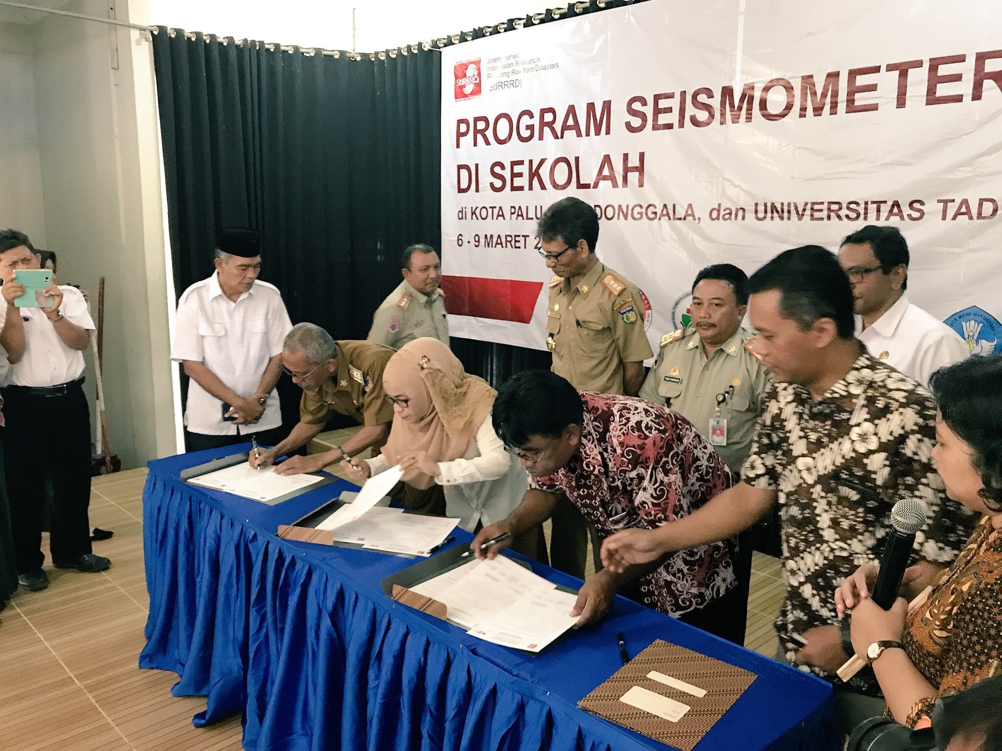
Importantly, the project has been supported by a range of Indonesian agencies willing to assist the schools with technical support and further training. Their commitment was recognised in a MoU signing ceremony on 5 March. The agencies signing the MoU include:
Palu’s local university – Universitas of Tadulako (UNTAD)
The provincial office of the national seismic monitoring agency – Kantor Stasiun Geofisika Palu (BMKG)
The local emergency management offices – BPBD Kota Palu & BPBD Kabupaten Donggala
The provincial office of the national education office – Dinas Pendidikan Provinsi Sulawesi Tengah
The provincial office of the national Ministry of Religion – Kakanwil Kemenag Provinai Sulawesi Tengah
Principals from SIS schools in Palu and Donggala sign the MoU with other agencies
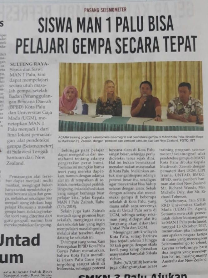
Local Palu newspaper report detailing the SIS pilot activity
All agencies were very enthusiastic about the SIS programme and agreed to help with technical assistance, further capacity building for teachers, help with assessing earthquake traces and providing ideas on how students might develop future projects. This enthusiasm was further reflected by the extensive media coverage the project received during the week in Palu, some which can be found here:
Opening ceremony and morning session at SMA Negeri model Terpadu Madani school, Palu
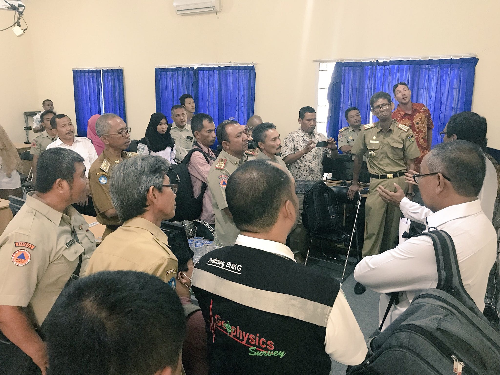
On Tuesday 6 March, the StIRRRD team visited SMA Negeri Model Terpadu Madani where an initial ceremony was followed by an overview of local seismic hazards and risks and capacity building for teachers and a group of selected students. This session was largely delivered by Universistas Gadjah Mada (UGM), StIRRRD team members and a representative from LIPI – Indonesia’s Institute of Science. Teachers and students were highly engaged during the session, while enjoying New Zealand chocolate for answering questions correctly, which was followed by a visit to the recently installed seismometer. In the afternoon, members of the StIRRRD team led targeted training session for the teachers with input from the agencies noted above. A demonstration of how the seismometer works by a technician from GNS Science was well received and ideas for future student projects was discussed with teachers.
The Head of Central Sulawesi BMKG and GNS Science technician, Richard Johnson, demonstrate a seismometer and equipment to the school principals and partner agencies
The same programme was delivered to MAN 1 in Palu City and SMA N 1 Banawa in Donggala on 7 and 8 March respectively. A highlight was returning to Donggala on Thursday and discovering that their seismometer had already detected its first earthquake the night before! The last seismometer to be installed in SMA N 1 Bahadopi school in Morowali will happen in coming weeks by UGM staff and technicians assisted by BMKG.
SMA N1 Banawa school in Donggala recorded their first earthquake on the recently installed seismometer
All of the seismometers are now part of the global raspberry shake seismic network with real time data from each of the devices available here: http://raspberyshake.net/stationview
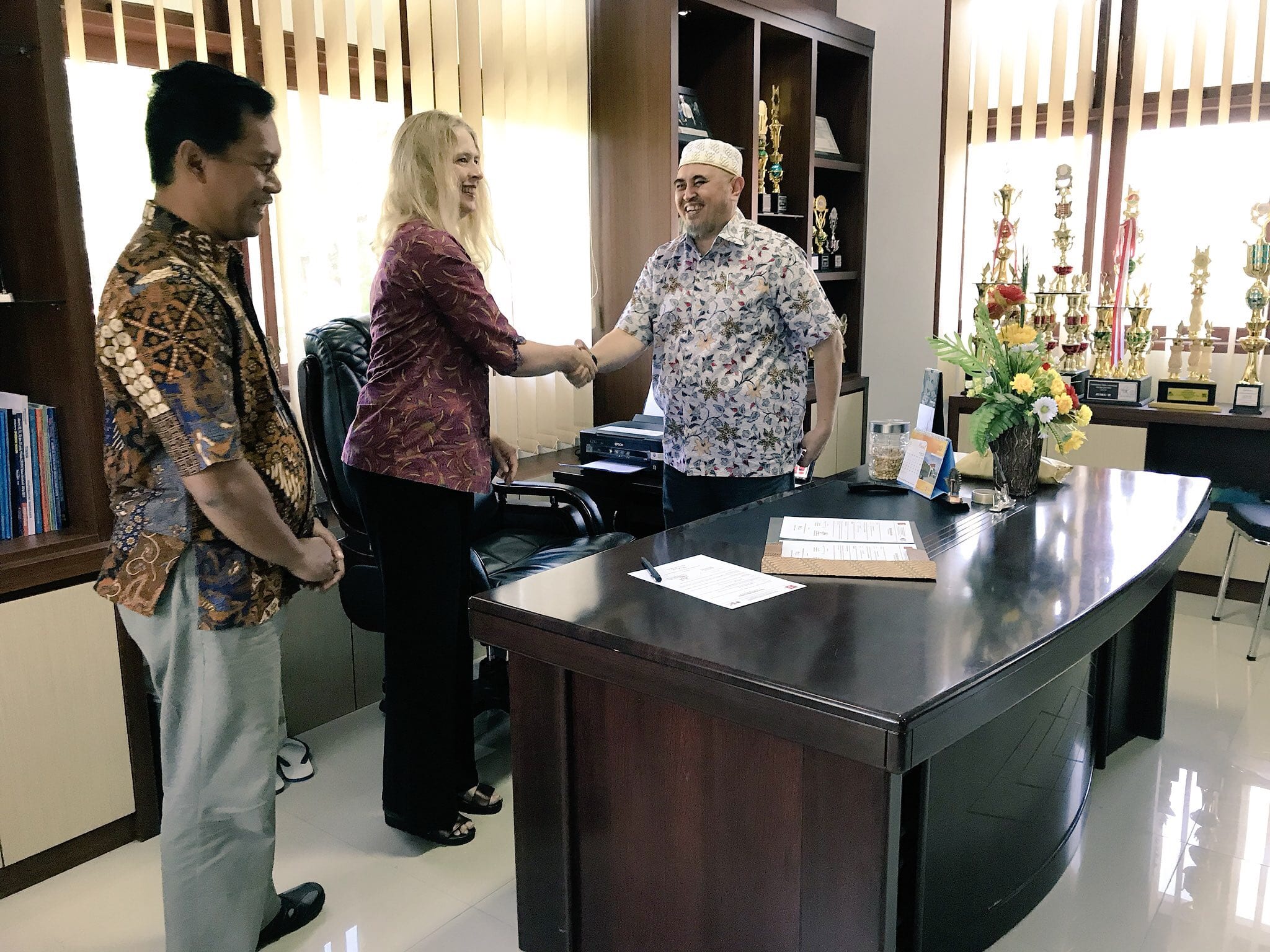
On Friday 9 March, the team completed the installation of a more sophisticated three-component seismometer at the Universitas of Tadulako (UNTAD). This device will support future research projects on the seismicity of the area and provide further data for the local Palu-Koro Fault seismic network managed by BMKG.
The Dean of Engineering from UNTAD with StIRRRD team members Michele and Pak Agung
That morning, StIRRRD team members met with the Dean of the Engineering and faculty staff to sign an MoU between UGM and UNTAD in support of the Seismometers in Schools programme in Central Sulawesi. There was much discussion on the disaster management international conference that UNTAD will host in November. The conference will coincide with the final evaluation of the SIS pilot project and StIRRRD team will have a very active presence at this event, including having a key note speaker.
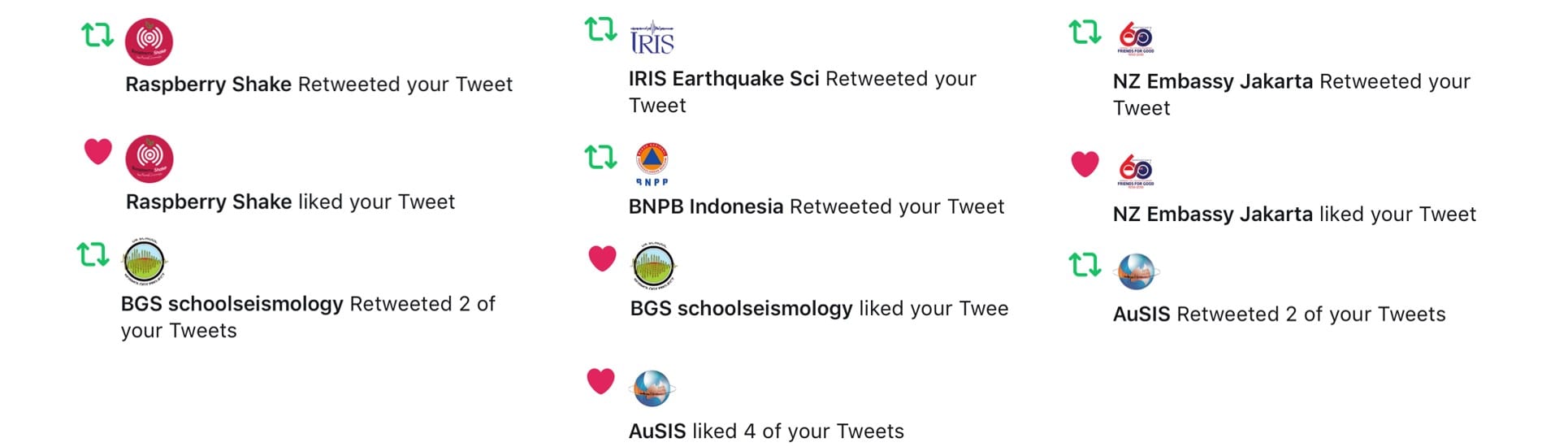
Overall, there was a lot of excitement about the new seismometers and opportunities to increase the capacity of teachers and knowledge of the high seismic risk present in Palu and Donggala. This interest was reflected with high engagement across social media (Twitter) with the national emergency management ministry (BNPB), the New Zealand embassy in Jakarta and the Universitas of Tadulako regularly liking and retweeting @StIRRRD tweets throughout the pilot deployment. Globally, organisations such as the Raspberry Shake Seismometer network (based in Panama), Australian SIS project, the IRIS earthquake programme (based in Washington) and the British Geological Survey seismology project were also very engaged by commenting, liking and retweeting our posts all week!
Twitter activity from @StIRRRD during the installation week
Strengthened Indonesian Resilience – Reducing Risk from Disasters


 Activities Summary
 Tsunami Damage Observations
Building and infrastructure damage was observed during recognisance along the coastline from Tawaeli to Palu City. The survey team made two stops at Port of Pantoloan and Kampung Nelayan based on the recommendations of UNTAD colleagues. Damage characteristics were observed but not systematically recorded using a field data collection application.
Tsunami Damage Observations
Building and infrastructure damage was observed during recognisance along the coastline from Tawaeli to Palu City. The survey team made two stops at Port of Pantoloan and Kampung Nelayan based on the recommendations of UNTAD colleagues. Damage characteristics were observed but not systematically recorded using a field data collection application.
 Buildings
 Noted that the ferry service was moved to another further north port prior the Palu-Dongala earthquake tsunami, hence limited human impact during the event.